| Canyon
Reservoir Tailrace BVET Habitat Survey 2006 |
Large
Woody Debris Summary |
|
|
|
|
|
|
|
|
|
|
No. per |
|
| Survey Distance (km) |
17.1 |
|
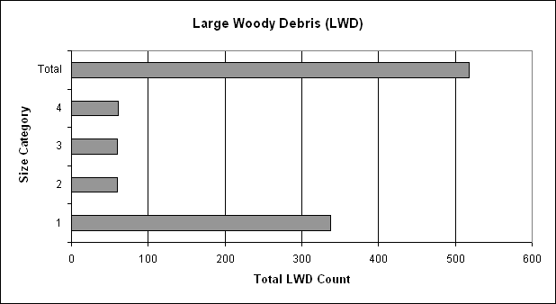
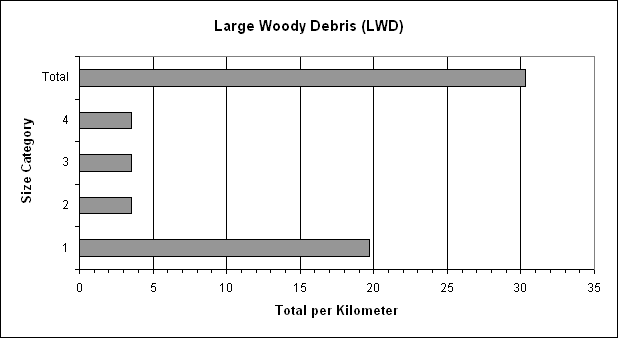
Category |
Length (m) |
Diameter (cm) |
Description |
Total(s) |
Kilometer |
|
| Survey Acreage |
126 |
|
1 |
1-5 |
10-55 |
short, skinny |
337 |
20 |
|
|
2 |
1-5 |
>55 |
short, fat |
60 |
4 |
|
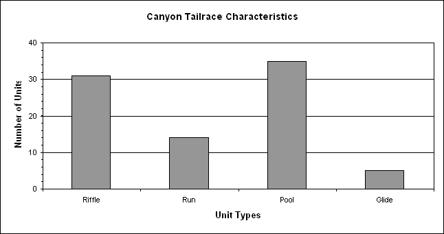
| Unit |
Number |
Total |
Percent |
Linear |
Percent |
Riffle/Run |
Pool/Glide |
3 |
>5 |
10-55 |
long, skinny |
60 |
4 |
|
| Type |
of Units |
Acres |
Coverage |
Distance (m) |
Composition |
Ratio |
Ratio |
4 |
>5 |
>55 |
long, fat |
61 |
4 |
|
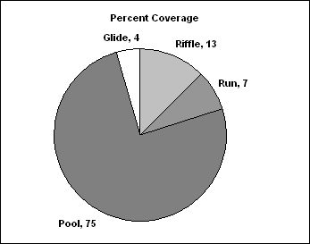
| Riffle |
31 |
16 |
13 |
2355 |
36 |
69 |
|
Total |
|
|
518 |
30 |
|
| Run |
14 |
9 |
7 |
1488 |
16 |
31 |
|
| Pool |
35 |
95 |
75 |
12410 |
41 |
|
88 |
|
|
| Glide |
5 |
5 |
4 |
651 |
6 |
|
13 |
|
| Total(s) |
85 |
126 |
100 |
16904 |
100 |
100 |
100 |
|
|
|
|
|
|
|
|
|
|
|
|
|
|
|
|
|
|
|
|
|
|
|
|
|
|
|
|
|
|
|
|
|
|
|
|
|
|
|
|
|
|
|
|
|
|
|
|
|
|
|
|
|
|
|
|
|
|
|
|
|
|
|
|
|
|
|
|
|
|
|
|
|
|
|
|
|
|
|
|
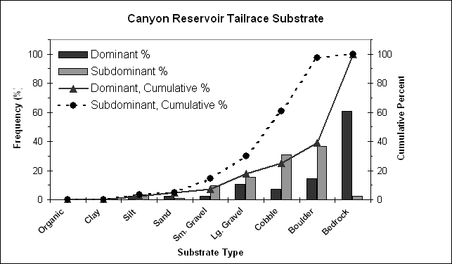
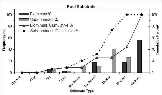
| Substrate |
|
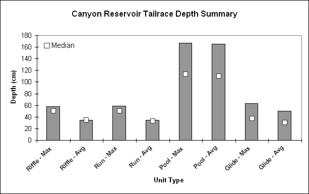
Depth Summary |
|
|
|
|
|
|
|
| 0.0 - 17.1 km |
|
Unit |
Average Depth |
Median |
|
| Substrate |
Substrate |
Units Present |
Percent Composition |
Cumulative Percent |
Type |
Maximum |
Average |
Maximum |
Average |
|
| Type |
Number |
Dominant |
Subdominant |
Dominant |
Subdominant |
Dominant |
Subdominant |
Riffle - Max |
58 |
35 |
50 |
35 |
|
| Organic |
1 |
0 |
0 |
0 |
0 |
0 |
0 |
Run - Max |
59 |
35 |
50 |
33 |
|
|
|
| Clay |
2 |
0 |
0 |
0 |
0 |
0 |
0 |
Pool - Max |
167 |
165 |
113 |
110 |
|
|
|
| Silt |
3 |
2 |
3 |
2 |
4 |
2 |
4 |
Glide - Max |
63 |
50 |
37 |
30 |
|
|
|
| Sand |
4 |
2 |
1 |
2 |
1 |
5 |
5 |
|
|
|
| Sm. Gravel |
5 |
2 |
8 |
2 |
10 |
7 |
14 |
|
| Lg. Gravel |
6 |
9 |
13 |
11 |
15 |
18 |
30 |
|
| Cobble |
7 |
6 |
26 |
7 |
31 |
25 |
61 |
|
|
| Boulder |
8 |
12 |
31 |
14 |
37 |
39 |
98 |
|
Riffle - Max |
58 |
|
50 |
|
| Bedrock |
9 |
51 |
2 |
61 |
2 |
100 |
100 |
|
Riffle - Avg |
35 |
|
35 |
|
| Total(s) |
|
84* |
84* |
100 |
100 |
|
Run - Max |
59 |
|
50 |
|
| *Only
GPS data recorded for Pool 35 |
|
Run - Avg |
35 |
|
33 |
|
|
Pool - Max |
167 |
|
113 |
|
|
Pool - Avg |
165 |
|
110 |
|
|
Glide - Max |
63 |
|
37 |
|
|
Glide - Avg |
50 |
|
30 |
|
|
|
|
|
|
|
|
|
|
|
|
|
|
|
|
|
|
|
|
|
|
|
|
|
|
|
|
|
|
|
|
|
|
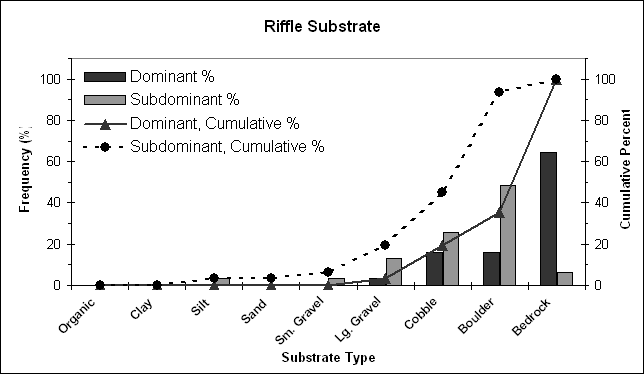
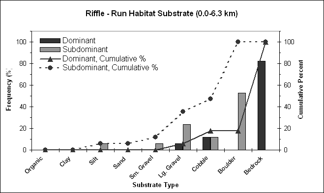
| Riffle
Substrate |
|
Habitat Suitability Model - V4 (Thalweg Depth) |
|
| Substrate |
Substrate |
Units Present |
Percent Composition |
Cumulative Percent |
|
| Type |
Number |
Dominant |
Subdominant |
Dominant |
Subdominant |
Dominant |
Subdominant |
0.0-17.1 km |
|
|
| Organic |
1 |
0 |
0 |
0 |
0 |
0 |
0 |
Average Maximum Depth (cm) |
|
102 |
|
| Clay |
2 |
0 |
0 |
0 |
0 |
0 |
0 |
Suitability Index |
|
>=1.0 |
|
| Silt |
3 |
0 |
1 |
0 |
3 |
0 |
3 |
|
|
| Sand |
4 |
0 |
0 |
0 |
0 |
0 |
3 |
0.0-6.3 km |
|
|
| Sm. Gravel |
5 |
0 |
1 |
0 |
3 |
0 |
6 |
Average Maximum Depth (cm) |
|
118 |
|
| Lg. Gravel |
6 |
1 |
4 |
3 |
13 |
3 |
19 |
Suitability Index |
|
>=1.0 |
|
| Cobble |
7 |
5 |
8 |
16 |
26 |
19 |
45 |
|
|
| Boulder |
8 |
5 |
15 |
16 |
48 |
35 |
94 |
6.3-11.7 km |
|
|
| Bedrock |
9 |
20 |
2 |
65 |
6 |
100 |
100 |
Average Maximum Depth (cm) |
|
88 |
|
| Total(s) |
|
31 |
31 |
100 |
100 |
|
Suitability Index |
|
>=1.0 |
|
|
|
|
|
11.7-17.1 km |
|
|
|
Average Maximum Depth (cm) |
|
103 |
|
|
Suitability Index |
|
>=1.0 |
|
|
|
|
|
|
|
|
|
|
|
|
|
|
|
|
|
|
|
|
|
|
|
|
|
|
|
|
|
|
|
|
|
|
|
|
|
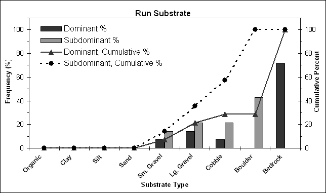
| Run Substrate |
|
Habitat Suitability Model - V10 (Percent Pools) |
|
| Substrate |
Substrate |
Units Present |
Percent Composition |
Cumulative Percent |
|
| Type |
Number |
Dominant |
Subdominant |
Dominant |
Subdominant |
Dominant |
Subdominant |
0.0-17.1 km |
|
Percent Pools: |
47 |
|
| Organic |
1 |
0 |
0 |
0 |
0 |
0 |
0 |
Unit |
Number |
Percent |
|
Suitability Index: |
>= 1.0 |
|
| Clay |
2 |
0 |
0 |
0 |
0 |
0 |
0 |
Type |
of Units |
Composition |
|
|
| Silt |
3 |
0 |
0 |
0 |
0 |
0 |
0 |
Riffle |
31 |
36 |
|
|
| Sand |
4 |
0 |
0 |
0 |
0 |
0 |
0 |
Run |
14 |
16 |
|
|
| Sm. Gravel |
5 |
1 |
2 |
7 |
14 |
7 |
14 |
Pool |
35 |
41 |
|
|
| Lg. Gravel |
6 |
2 |
3 |
14 |
21 |
21 |
36 |
Glide |
5 |
6 |
|
| Cobble |
7 |
1 |
3 |
7 |
21 |
29 |
57 |
Total(s) |
85 |
100 |
|
|
| Boulder |
8 |
0 |
6 |
0 |
43 |
29 |
100 |
|
|
| Bedrock |
9 |
10 |
0 |
71 |
0 |
100 |
100 |
0.0-6.3 km |
|
Percent Pools: |
41 |
|
| Total(s) |
|
14 |
14 |
100 |
100 |
|
Unit |
Number |
Percent |
|
Suitability Index: |
>= 1.0 |
|
|
Type |
of Units |
Composition |
|
|
|
Riffle |
12 |
41 |
|
|
|
Run |
5 |
17 |
|
|
|
|
Pool |
10 |
34 |
|
|
|
Glide |
2 |
7 |
|
|
|
Total(s) |
29 |
100 |
|
|
|
|
|
|
|
6.3-11.7 km |
|
|
|
Unit |
Number |
Percent |
|
Percent Pools: |
55 |
|
|
Type |
of Units |
Composition |
|
Suitability Index: |
>= 1.0 |
|
|
Riffle |
10 |
30 |
|
|
|
Run |
5 |
15 |
|
|
|
Pool |
15 |
45 |
|
|
|
Glide |
3 |
9 |
|
|
|
Total(s) |
33 |
100 |
|
|
|
|
|
|
11.7-17.1km |
|
|
|
Unit |
Number |
Percent |
|
Percent Pools: |
43 |
|
|
Type |
of Units |
Composition |
|
Suitability Index: |
>= 1.0 |
|
|
Riffle |
9 |
39 |
|
|
|
Run |
4 |
17 |
|
|
|
Pool |
10 |
43 |
|
|
|
Glide |
0 |
0 |
|
|
|
Total(s) |
23 |
100 |
|
|
|
|
|
|
|
|
|
|
|
|
|
|
|
|
|
Habitat Suitability Model - V15 (Pool Class Rating) |
|
| Pool
Substrate |
|
| Substrate |
Substrate |
Units Present |
Percent Composition |
Cumulative Percent |
Unit |
Number |
|
|
| Type |
Number |
Dominant |
Subdominant |
Dominant |
Subdominant |
Dominant |
Subdominant |
Type |
of Units |
|
|
| Organic |
1 |
0 |
0 |
0 |
0 |
0 |
0 |
Glides |
5 |
|
|
| Clay |
2 |
0 |
0 |
0 |
0 |
0 |
0 |
Pools |
35 |
|
|
| Silt |
3 |
2 |
2 |
6 |
6 |
6 |
6 |
Total |
40 |
|
|
| Sand |
4 |
1 |
1 |
3 |
3 |
9 |
9 |
|
|
| Sm. Gravel |
5 |
0 |
4 |
0 |
12 |
9 |
21 |
Depth >=200cm |
|
15 |
|
| Lg. Gravel |
6 |
6 |
4 |
18 |
12 |
27 |
32 |
|
|
| Cobble |
7 |
0 |
14 |
0 |
41 |
27 |
74 |
Pool Class Rating (1st
Class >=30%) |
|
38 |
|
| Boulder |
8 |
6 |
9 |
18 |
26 |
44 |
100 |
|
|
| Bedrock |
9 |
19 |
0 |
56 |
0 |
100 |
100 |
Suitability Index |
|
A |
|
| Total(s) |
|
34* |
34* |
100 |
100 |
|
|
| *Only
GPS data recorded for Pool 35 |
|
|
|
|
|
|
|
|
|
|
|
|
|
|
|
|
|
|
|
|
|
|
|
|
|
|
|
|
|
|
|
|
|
|
|
|
|
|
|
|
| Glide
Substrate |
|
| Substrate |
Substrate |
Units Present |
Percent Composition |
Cumulative Percent |
|
| Type |
Number |
Dominant |
Subdominant |
Dominant |
Subdominant |
Dominant |
Subdominant |
|
| Organic |
1 |
0 |
0 |
0 |
0 |
0 |
0 |
|
| Clay |
2 |
0 |
0 |
0 |
0 |
0 |
0 |
|
| Silt |
3 |
0 |
0 |
0 |
0 |
0 |
0 |
|
| Sand |
4 |
1 |
0 |
20 |
0 |
20 |
0 |
|
| Sm. Gravel |
5 |
1 |
1 |
20 |
20 |
40 |
20 |
|
| Lg. Gravel |
6 |
0 |
2 |
0 |
40 |
40 |
60 |
|
| Cobble |
7 |
0 |
1 |
0 |
20 |
40 |
80 |
|
| Boulder |
8 |
1 |
1 |
20 |
20 |
60 |
100 |
|
| Bedrock |
9 |
2 |
0 |
40 |
0 |
100 |
100 |
|
| Total(s) |
|
5 |
5 |
100 |
100 |
|
|
|
|
|
|

|
|
|
|
|
|
|
|
|
|
|
|
|
|
|
|
|
|
|
|
|
|
|
|
|
|
|
|
|
|
|
|
|
|
|
|
| Habitat Suitability
Model - V9 (Food Production) |
|
| 0.0
km - 6.3 km |
|
| Substrate |
Substrate |
Units Present |
Percent Composition |
Cumulative Percent |
|
| Type |
Number |
Dominant |
Subdominant |
Dominant |
Subdominant |
Dominant |
Subdominant |
|
| Organic |
1 |
0 |
0 |
0 |
0 |
0 |
0 |
|
| Clay |
2 |
0 |
0 |
0 |
0 |
0 |
0 |
|
| Silt |
3 |
0 |
1 |
0 |
6 |
0 |
6 |
|
| Sand |
4 |
0 |
0 |
0 |
0 |
0 |
6 |
|
| Sm. Gravel |
5 |
0 |
1 |
0 |
6 |
0 |
12 |
|
| Lg. Gravel |
6 |
1 |
4 |
6 |
24 |
6 |
35 |
|
| Cobble |
7 |
2 |
2 |
12 |
12 |
18 |
47 |
|
| Boulder |
8 |
0 |
9 |
0 |
53 |
18 |
100 |
|
| Bedrock |
9 |
14 |
0 |
82 |
0 |
100 |
100 |
|
| Total(s) |
|
17 |
17 |
100 |
100 |
|
|
|
|
|
|
|
|
|
|
|
|
|
|
|
|
|
|
|
|
|
|
|
|
|
|
|
|
|
|
| Predominant
substrate type (>= 50%) |
|
| 0.0- 6.3 km |
|
Bedrock |
|
|
| Suitability
Index |
C |
|
|
|
|
|
|
|
|
|
|
| Habitat Suitability
Model - V9 (Food Production) |
|
| 6.3 - 11.7 km |
|
|
| Substrate |
Substrate |
Units Present |
Percent Composition |
Cumulative Percent |
|
| Type |
Number |
Dominant |
Subdominant |
Dominant |
Subdominant |
Dominant |
Subdominant |
|
| Organic |
1 |
0 |
0 |
0 |
0 |
0 |
0 |
|
| Clay |
2 |
0 |
0 |
0 |
0 |
0 |
0 |
|
| Silt |
3 |
0 |
0 |
0 |
0 |
0 |
0 |
|
| Sand |
4 |
0 |
0 |
0 |
0 |
0 |
0 |
|
| Sm. Gravel |
5 |
1 |
1 |
7 |
7 |
7 |
7 |
|
| Lg. Gravel |
6 |
1 |
1 |
7 |
7 |
13 |
13 |
|
| Cobble |
7 |
1 |
5 |
7 |
33 |
20 |
47 |
|
| Boulder |
8 |
2 |
6 |
13 |
40 |
33 |
87 |
|
| Bedrock |
9 |
10 |
2 |
67 |
13 |
100 |
100 |
|
| Total(s) |
|
15 |
15 |
100 |
100 |
|
|
|
|
|
|
|
|
|
|
|
|
|
|
|
|
|
|
|
|
|
|
|
|
|
|
|
|
|
| Predominant
substrate type (>= 50%) |
|
| 6.3-11.7km |
|
Bedrock |
|
| Suitability
Index |
C |
|
|
|
|
|
|
|
|
|
|
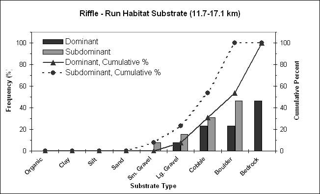
| Habitat Suitability
Model - V9 (Food Production) |
|
| 11.7 - 17.1 km |
|
|
| Substrate |
Substrate |
Units Present |
Percent Composition |
Cumulative Percent |
|
| Type |
Number |
Dominant |
Subdominant |
Dominant |
Subdominant |
Dominant |
Subdominant |
|
| Organic |
1 |
0 |
0 |
0 |
0 |
0 |
0 |
|
| Clay |
2 |
0 |
0 |
0 |
0 |
0 |
0 |
|
| Silt |
3 |
0 |
0 |
0 |
0 |
0 |
0 |
|
| Sand |
4 |
0 |
0 |
0 |
0 |
0 |
0 |
|
| Sm. Gravel |
5 |
0 |
1 |
0 |
8 |
0 |
8 |
|
| Lg. Gravel |
6 |
1 |
2 |
8 |
15 |
8 |
23 |
|
| Cobble |
7 |
3 |
4 |
23 |
31 |
31 |
54 |
|
| Boulder |
8 |
3 |
6 |
23 |
46 |
54 |
100 |
|
| Bedrock |
9 |
6 |
0 |
46 |
0 |
100 |
100 |
|
| Total(s) |
|
13 |
13 |
100 |
100 |
|
|
|
|
|
|
|
|
|
|
|
|
|
|
|
|
|
|
|
|
|
|
|
|
|
|
|
|
|
|
| Predominant
substrate types occur in approximately equal amounts |
|
|
| 11.7-17.1 km |
|
Lg. Gravel, Cobble, Boulder (54% of substrate) |
|
|
|
|
Bedrock (46% of substrate) |
|
|
| Suitability
Index |
B / C |
|
|
|
|
|
|
|
|
|
|
|
|
|
|
|
|
|
|
|
|